on spokes
... And we left
From the Center Vorohty Zaroslyak sports base to approximately 21 kilometers of road. In order not to execute the whole day just to overcome this distance, you must use the road. Buses and minibuses from Ivano-Frankivsk and runs to Vorohty Verhoviny from seventh in the morning. In Vorochta can order a car to Zaroslyak (it cost a hundred USD). Slightly
more than 12 miles from Vorohty in Zavoyelya tract, is the checkpoint
of the Carpathian national natural park and a tourist haven. At the checkpoint tourists pay small fees.
Recently, National Park information booths equipped, updated layout tracks, which facilitates targeting. Not as much as nine miles from the CPR - and we in Zaroslyak. The most popular ascent from here - in a westerly direction, Goverlu. We
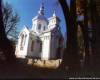
return to the left - passing through the bridge near the chapel and
moving south serpentine road, paved before the First World War, at the
foot of the mountain Pozhyzhevska (1822 feet), where the two objects -
Highlands hospital Carpathian Institute of Ecology, National Academy of
Sciences of Ukraine sniholavynna and meteorological station. Winter at a hospital from time to time naviduyetsya staff, but the weather station is open all year.
Slow recovery from Zaroslyak to the hospital took just 35 minutes. From
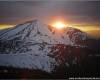
this point on the north-west is visible Goverlu (2061 meter) and
Breskul (1912 meters) in the south - Mount Dantsizh (1848 meters). To
boisterousness (another name - Turkul - from the mountains (1933 feet)
that rises above it) from meteorological stations can take two paths:
Montenegrin ridge, rising to the top of Pozhyzhevska, past and Dantsizh
Turkul to the boundary column number 32, or downward, trasovanoyu shestykilometrovoyu path that begins south institute hospital. You have a stand with a description of the route and information about the lake. The same stand behind half a mile before the lake at the fork. Staff meteorological advised to go downward. The
path, among others, is suitable for bicycle trips (but not in winter!),
It also laid by the Austro-Hungarian Empire, and now clearly
promarkovana, has steep ups-slopes, cleared of trees prostrate. Fall two-hour walk in this segment seems very interesting and educative. Somewhere
in the middle, near Dantsizha, we noticed signs of climbing snow
avalanches assumed that winter and spring is a dangerous place.
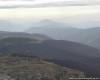
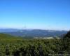
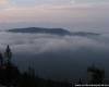
Fragment Chornogory
Legendary Nesamovite seems nasolodzhuvalosya last warm days. The parable says: if you throw a stone into the water - remove the storm. Again peresvidchuvatysya this we were not going - no need to provoke Whit mountains. Instead, Taras, our photographer captured fiksuvav on "film" and "number" unique autumn scenes around the lake. (Planning
the trip, we predicted the time of photo session, but the first day did
not have enough hours to daylight rozklastysya overnight in
pre-designated place).
Actually,
the backbone of Montenegro, from 32-th column over the Crazy to the
left turn to the northeast, to the spokes, less than two kilometers. Behind - unusual for participants in the massive climbing angle - Lunch. Light cloud barely conceals pole on top. Ahead - another Carpathian dvotysyachnyk, Rib Mountain. (To understand why it ribs, have a look at the bottom of the mountain from the eastern side of the ravine Hadzhyna). Left on rocky ridges of two paths - Small and Large Kizly. Not reaching to the correct landmark, column number 30, we turned traverses northeast, parallel to the Great Kizliv. Because we were there the first time, and clear visibility could be wrong. Another thing, when you get in the fog, you can zblukaty for some hundreds of meters.
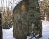
The key point
Spokes were the main point of our trip. From
the west ridge, which departs from Chornogory, smooth, flat, grassy,
scrubby bushes carpet bilberries and cranberries, and to the east -
precipices, from which the whole ridge rises sheer, bizarre rock forms.
Eastern
spurs ribs and spokes form is almost impenetrable wall of original
boiler, which is marked on the map as tract Hadzhyna. Tourists rarely get here. We
know only one tourist complex - "Legend of the Carpathians" (CBS city
of Ivano-Frankivsk region) - which, among others, offers a walking
trail from the village of increased complexity Bystrets Verhovinskogo
area to mount spokes. Not en masse, as in Bubnyschi, rock-climbing naviduyutsya here. Summer Hadzhyni hutsuly Bystrets pasturing the flock of cows, horses and sheep. One curious case once told us a local shepherd: "Several bystretskyh pohostylysi and climbed on the spokes. A yiden was on a rock, look - a hanging cord. He pulled and zdolyny hear: "Dadya, provides nye!". Well, However, everything was good ....
Once we saw the rock as the east nasunuv fog. Stone giants are only occasionally vymalovuvalysya of darkness. Zasivshy in the trenches during WWI, expected wait, when the clouds pass over the west. But there has been sun hylylosya the horizon, so decided to go down. Pass from the spokes to Hadzhyny summer only rapid, overgrown grass on the northeast slope of rocks. If rainy weather, no guarantee of not falling. So surely requires reliable footwear. (In winter, downhill and this is often not available.)
Starting descent, disable mobile phones - no signal at the bottom. East on the grass, trying to come across the path, which lost a little below the extreme rock. The path takes to the stream. Since it goes any branch of the right, but you should not go there - these uncertain path rising in impenetrable zherep. Sutenilo, so decided to unfold the tent. Morning at spokes was a wonderful. Another photo-opps, and we abandon sorrow Hadzhynu.
From our restaurant to our restaurant
The
path leads past a large solitary stone, along the right bank of the
stream Mreye prints on the meadow, where there-done parking bystretskyh
shepherds (wooden building a few rooms, bulb, fold). Here we first planned park. People and animals have left this place a few weeks ago, before next summer. But in the restaurant - twang budze (vudzhenoho cheese) and dried mushrooms. Owners of stocks left the wood, salt, apples pryv'yali filled loyem nightlight. Above the door - the icon. On one wall the words four years ago: "Thank God and the people who put this kolybu. 13.10.01 ...». In addition - the religious calendar.
Hence,
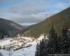
the east is the road to Bystrets (approximately 10 kilometers)
northeast mountain Kostricha clearly visible, which also are
outbuildings. We pidnimayemosya from our restaurant on the north side of the mountain Maryshevska Great (1564 feet). We
proceed to the meadow where the left, on the edge of the forest, begins
quite fuzzy forest trail through the tract Marixie to the same hill
(1340 meters). First on the trail often occur down trees in the forest, we continue to lose, potratyvshy probably half an hour to walk. Please be aware: the path goes east slopes, on the left hand - the rise, right - a steep slope. Y-direction - north-northeast. Then the road better. It all left branch somehow lead the way on Zaroslyak. Elevation to Marixie sloping mountains. And for a few meters before the top goes to the crotch traversnoyi paths. The road to the right - to Mount Kostricha, left - to the hospital of Geography Department of the Lviv University. We go toward the hospital, north-west. Along the way collect mushrooms.
A
little more than an hour to go out on the right bank of the Prut River
embankment of the former narrow, then - down the stream, passing
Gamekeeper, proceed past the hospital on the road. Left - forelne economy, which for several years of decline it began to recover. Below this sector in the Prut flows into the flow Foreschynka (tract Babin Yama). From
here you can start climbing Kukule (just over a kilometer along the
stream to the wooden structure, more rapid recovery chotyrykilometrovyy
northwest).
However, we chose a different path. Just
two miles the road toward the checkpoint located to the right side of
the house, which is the inscription "Mariychyna bulb. Quite
the opposite of this court beginning guided trail phenological *, which
indicates the appropriate space, is equipped with space for recreation.
Ideally, we had to get up the mountain Kukule and spend the night near the bulb. And again because we have enough time to climb, staying here.
Paradise for pets and ... skiers
In
the morning of the third day with fresh forces, we have overcome quite
a steep climb to trykilometrovyy Kukule hour and 10 minutes. In a wide lawn near the border of the forest is great - though Dance - bulb from the fold. Elevation at the summit (1539 feet) starts near the high wooden cross. After Kukule is an old Czech-Polish border (the current limit of Ivano-Frankivsk and Transcarpathian).
Go be a peak, but obihnuty it traverses the south piznavalnishe. Clear
path kolybu pass through the forest and comes across some three hundred
meters to the crotch - just to the left path leads to the ravine Babi
Yama. And a few hundred meters traversnu path crosses the border (column number 10 / 7). On the border of the shortest path to Kukule Goverly, but it is extremely difficult, with almost kilometer height. Traversna trail takes us to a great mountain Kukule, where hundreds of summer pasturing the flock of cattle. There are dozens of buildings, including with stone stoves.
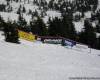
In winter the shepherds never closes the bulb, and then ski lovers sometimes they settle for a few days. Typically, mountain Kukule winter climb of Voronenko, it takes all day. Skiers zanochovuyut in the restaurant and go out in the next day. However, there fans who like a night slalom - monthly frosty night with flashlight on his head. Gentle slopes and no stones ear for this is provided.
Almost
the entire route from Kukule to Voronenko (from the top to the railway
station less than 15 kilometers) runs a clear road that goes to the
tunnel. The only place you can go wrong - right turn near the border column number 20. Boundary line is clearly in the north and passes over the tunnel and road to the village returns to the northeast. Famous TRANSCARPATIAN tram, train, Rachel - Ivano-Frankivsk, departing from Voronenko 17.00.?
Tips advanced
Vasily Zavalko, head of the Ivano-Frankivsk Federation of mountaineering and climbing:
- Those who are sent here in the summer, counsel must have-done trekking shoes, coats or coats of rain, reserve stock of food. Winter is not a reliable guide in general you can not go. This section Chornogory and Gorgan - not for beginners.
Michael Sopriyanchuk, instructor in mountaineering, rock climbing with CMS (g.Kosiv):
- It spoke about the natural mountain faults attract the most precipitation. Great danger east eaves. It used to be winter, stand on equal ground and suddenly we hear how the earth - begins to descend avalanche. In the winter of spokes can take only one ridge, past the mountain Homul. If you do not suicide, then there is no conductor phaytesya.
|