Around Yaremche
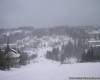
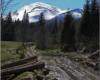
Makovytsya. From three hundred to three
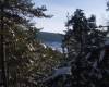
This mount (984, 5 meters) in cloudless weather saw more from the village of Dora everyone who enters to Yaremche train or car. It towers over the town to the east. On top of Bald set high cross.
Since
the middle of last century, since Yaremcha zahodylysya make the center
of tourism and recreation, pedestrian routes Makovytsya became one of
the most popular. Elevation
at the top does not require much effort, and landscapes that open with
it, believe me, the more worthwhile - it begins here for many love to
the Carpathians. Get off at the top can and three baby and elderly people.
The
shortest path to Makovytsya - with Yamny along stream Makivchyk, almost
to the north and northeast (about 4.5 kilometers in length). But
seems interesting trip from the railway station in Yaremche (in the
direction of that same Yamny), ascent road through the center of town
past the souvenir market, before the bridge is located on the coast of
the Prut. (You can make a small hook and to admire the waterfall tests). From the station the way we should go about two miles.
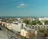
Marked path to the crown begins on the left side of road almost opposite the waterfall before a steep left turn. On the road falls are not visible, only to hear the sound of water. The first forty minutes, lifting a little bit difficult, the path leads among the rocks, forming natural steps. (Quadrennial kid has raised them by hand). But then you go to a small clearing where there is a huge stone. At one - many signed by visitors. Alternatively, in the form of parallelepiped, serves as an excellent table (there is also room for a fire). In the north-west through the branches of mixed forest before you open panorama Yaremche. On the other hand, with 300 meters to the east - new villas Yamny. And
next to the lawn on a slope on the right can come across the remnants
of guerrilla dugouts (square hole with a few rotten and moss-grown
logs).
Footpath
already polohisha, then leads to woods metal towers obihnuvshy that you
almost immediately go to an open area, to the mountain of hayfields. From
outside the forest abruptly left and down a path that runs back along
the ravine to the center Yaremche (just below the gully becomes
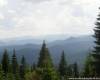
potichok). This path can go to the houses on the left bank of the Prut, go and find yourself near the city bus. But we are not left, we were right. Ahead, a kilometer and a half - Makovytsya. Before the very top - fork. From her traversna trail leads directly to Dora. Elevation at the summit takes a little force, but some minutes - and you're on the crown at the cross. Inspect
range Jawornik, proud silhouettes hamsters, bruises, extensive
Doboshanku the southwest and to the west at your feet - Yaremcha on the
horizon visible Synyachku mountain, in the northeast - Rokyta with
relay tower ...
With crowns, you can retrace the same route (as an option, referred to the path along the ravine). But some believe that to go our own footsteps - a sign of bad taste. Choose the way to the Douro, the top left of the slope, almost precisely at midnight.
So
you have two miles from Yaremche prevailed slightly less than five
kilometers of recovery, and now remains is less than five kilometers
pleasant descent. On
the slow journey from ohlyadynamy, respite, some entertainment, even
dinner campfire circle with interest enough for six hours, but most
only recovery path will take no more than two hours.
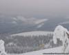
Synyachka.Mandrivka with variations
Synyachka mountain (1401 meters) is located to the northwest of Yaremche at a distance of seven miles in a straight line. But, of course, Carpathians - not Philadelphia - no direct roads.
Option A
Getting
on with Synyachku Yaremche can only pass through Pereslop, which is
also seven kilometers from the railway bridge over the Prut (here in
the Prut River flows into the left tributary, the river is very cold
Zhonka). Marked trail on Pereslop stretches for five kilometers left bank of the river in the upstream direction. At the beginning of a trip, you pass by the enclosures with nearly tame deer and funny pylon. Describe in detail the route make no sense - it is enough bullets and other pointers. Distavshys
Pereslopa, you will see the Soviet-era anachronism, silvery-red metal
structure that exalts "kapeeses, and napivrozvalenu wooden box, which
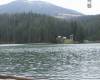
you can select the range of parking space. With
the pass scattered three ways: directly - Zelenytsya to the river,
along which-done (for the Carpathians) highway can get to the village
green, the left path leads through the tract Bukovets Jawornik on the
spine, right, heading north - the road to Synyachku. You'll see mountain meadows with Schivka (here over 60 years ago were fierce fighting guerrillas caps). To
reach the top, should obihnuty mountain from the south-west - go to the
open area, where several hundred meters are wagons and Technology of
Petroleum. Stony path to the top - right up. On the one that leads right down - eventually.
Option
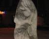
There are at least two reasons for having to go to Synyachky with Dora. One can find directly on top. On this mountain place of worship missionary monastery of St. Elias, which is Dori. (Elijah
is considered the lord of thunder, and then the tourists dokonche
recommended friends on this holiday, Dora residents believe their
Synyachku). Another
argument - startuyuchy with Dora, you most likely will pass by White
Stone (another name for Pierce, Dora, 961.5 meters), 29-meter height of
solid rock, a place of pilgrimage climbers (they usually train here)
and numerous tourists, including "matratsnykamy.
From
the Dora railway station via the circle, moving way past the village
church and cemetery, which rotate to the right, north, despite the
hayfields, more livishe through lawns and mixed forest. From the railway station to the rock about three miles. Around a place for parking - to the left of the road, four hundred meters in front of the White Stone hit the source. Private ROUTE characteristic steep rise. Without
an experienced instructor should not try to climb the cliff (to the
south is sheer, just here vpravlyayutsya athletes, and on the north
side may try to force fans). Always remember that down harder, that is worse than the climb. You
can fully equipped, with a quote Ilf Petrov, nauseating terror "as the
father of Principality of Theodoro, who, in vkravshy Ostap Bender piece
of sausage, vydersya on sheer rock, and their howling noise zahlushuvav
Terek.
Obihnuvshy south white stone, about three and a half miles proceed to oil machines. After one of the nearest turn left Synyachky panoramic view and two low ranges, stretching north. Go to the mountain more than three miles. It
will bypass traverses low, but steep hill-trodden path to approach the
foot Synyachky, and now from the north come to the same place from
which began the mountaineering in variant A. It is clear that it is in
the right path?
Option C
From Delyatyn to Synyachky longest road, but simple. She
should choose at least for the sake of sporting interests ¬ SUITE: pass
route Delyatyn-Synyachka-Dora mixed group (women and children) no
longer as seven hours, including rest and lunch. Another advantage of this route - it is quite suitable for a bicycle trip.
Beginning in Delyatyn three hundred meters south of the railway station. Paved the way for a small earthen vybyrayemos career. By him to the west dirt road shows to a mixed forest. Long stretches of sloping rise of about four miles. We proceed to the fork. Before us - the overgrown bushes, raspberries and blackberries former logging. Below, the north-west, visible surface structure of the military camp. This - the former secret facility of the Ministry of Defense of the USSR, where, say, whole echelons visited the ground. In
the town indicated postal address in Moscow, and the children of
servicemen allegedly studied at the Moscow school number 148. Now the object belongs to the Ukrainian military department, the proposals make it into a tourist establishment has shied away. The road leads right into the river Delyatyn Przemyśl, left - brings up the mountain, about a mile from the said oil wells. By the way, the backbone of this mountain road east out of the White Stones. Follow the route of the famous - torovanoyu way to move southwest to Synyachky.
Cyclists better to go past the base oil workers to leave the river and Zelenytsya in Green. For walking a different route.
No options. Return (D)
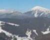
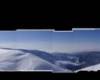
Elevation of Synyachku takes 20 minutes. Pomyluvavshys
with rocky peaks surrounding landscapes and postoyavshy missionary
circle cross rises in the south-easterly direction to the meadows
Schivka. Approximately kilometer move east, then take right and proceed to the forest covered ridge Chornohorytsya. In the Douro go seven miles. Somewhere in the middle of the road right panoramic view Yaremche, visible and Makovytsya. Go to town past the numerous estates of fence is not too convenient. Choose the right path, in the Douro. Ahead - a rather steep slope deciduous forest, but the path is clear. For that half an hour - we are in the village before the bridge over the river Kamenka. To the railway station one hundred meters. Packed in seven hours?
|