Two face Antalovetskoyi Polana
The first route passed through an array Antalovetska Polyana in late October. Offer
second trip to this same route in mid-November vischuvala is no
problem: the winter is far fields Precarpathian barely covered the
first snow, and Antalovetska Polyana in relatively warm Transcarpathia.
As
this happened - told by comparing two campaigns, so that our successors
can choose their own what they are closer to the soul.
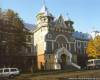
The road to the castle Nevitsky
Pedestrian route originates at a distance of ten kilometers from Uzhgorod. To
get to the regional center in Transcarpathia public transport in the
morning time to be available to all fall short daylight hours, you can
only train. In Ivano-Frankivsk Chernivtsi direct flight or passenger trains are only every four days. Lviv or Stryi choices, how to get to Uzhgorod, very wide. As the date for sending the train Chernovtsy, Uzhgorod we were approached, we took advantage of a transfer of Stryi. The
first rays of morning sun had already met in the village kamyanitsa -
arrived by minibus, which started from square Koryatovicha in the
regional capital of Transcarpathia. After crossing a wooden footbridge over hanging Already, a few minutes is quite steep slope storm the castle hill.
Nevitsky
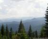
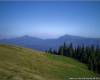
examines the ruins of the castle, make a few images remaining buildings
and beautiful landscapes, which opened here in the west. This, above all, the river valley and ridges Already Vihorlat volcanic massif, which continues in Slovakia.
From the castle we pass through recreation paved roads. She gradually znyzhuyuchys leads in an easterly direction to the stream bed. After half a mile asfaltivka crosses the stream and returns down over the right bank of the stream. From the beginning of the turn are two underground roads that pass along the stream to top.
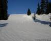
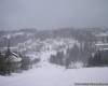
Snow Antalovetska Glade
Choose from two roads east, along the right bank. It is quite smooth, travel, even for cars. Three miles after turning approach to the quarterly column 33. Now - left abruptly in the north-west. Started soar.
During the second campaign we have not prypustylysya errors that made the first journey ...
This
time, desyatysantymetrovym covered with a layer of snow, it smoothly
and without incidents have brought us to point out the October -
pomerezhanoho traces timber branching roads. This time we, as then, very quickly from the road chosen one, which apparently gaining altitude in a southeasterly direction. On both sides of the line rather ozhynnyka dense thickets and young forests in place of the old carcass. Elevation is not very steep, but completely devoid of equal snippets, so tired his monotone. On the climb the snow hlybshaye. In addition, the top layer of loose, but underneath layer crust, in which the foot fails for another 10-15 centimeters. So lengthy - more than three miles - the rise was far more complex than in October. Finally we come to the old forest, where we would see a rapid bench top Antalovetska Polyana mountains. No special shoes every meter of the road is not easy to overcome ...
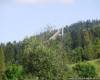
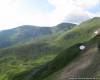
Zalisnenyy circuit bench tops are familiar way, which is sharply right and go straight towards the sun. Two
or three hundred meters race with snow - and before us opens lengthy
kotlovynopodibna lawn, which met in October, we dried herbs meters
high, and now - sparkling white blanket of snow. This is Antalovetska Polyana.
Concave
surface of the lawn, surrounded by a perimeter of the original shaft
makes it easy to believe that before us - the crater of the volcano,
which operated over millions of years ago. Detestable vytvoryla lava ledge east of the crater, which rise among the old beech forest. Here is the highest point of the mountain (968 meters). Tourists have marked her thick rod stuck into the ground.
The October sketches
Further routes will be provided shortly first in the October version. Then break and pomyluvavshys autumn colors lawn, climbed the highest point Antalovetskoyi glade. With
it, moving in a northerly direction, two or three dozen meters back out
on the field the way that departs from the northeast corner of lawn. She had brought us to the next interesting object - Rocky Sokolets complex. Hold the line watershed, forest road at first gently, but surely falls. Then slowly change the direction of the north-east and sets up a bit, avoiding the northern slopes of the top 886 meters. By the way it gradually takes a northerly direction and is almost horizontal ...
Avoiding
the puddles and mud on the road, we had to careful not to miss the
place where it converges with the path on the ridge Synatoria. With carelessness, we passed it ...
When they heard Uzhgorod help travelers find barely visible path that goes south-east forests. In her early on the tree is obsolete inscriptions red paint. Footpath rozhaluzhuyetsya halyavyntsi the small, overgrown grass growth in humans. We recommend to the left. After about 400 meters path takes a small halyavynku where again divided into two. Recommended livishoyu go. It vododilnoyu line Sokolych Mountain (812 meters) goes in the forest east ...
... Namyluvavshys views from the highest point of rocky complexes, descending along the cliff in a southeasterly direction. At the foot of cliffs at turns sharply right. Unfortunately, rare trees and shrubs not to photograph the rock Sokoltsya in all its beauty.
Moving under the rocks in the western part of them and seek the path that lead us from here is to glade. Sample paths barely noticeable, but so be sure to move northwestward, slowly typing height. Under the huge blocks, hanging up on the slope path becomes more pronounced. Go it primarily because we did not have no drop of water, and by description it should be near the source. Indeed, in 300-400 meters to believe it. Replenished water resources, starts the path that leads to top of the source in a northerly direction. After crossing two halyavynky with traces of camp tourists opynyayemosya near the junction.
Brief description of the route
Village
kamyanitsa - Nevitsky ruins of the castle - mountain Antalovetska
Polyana - Sokolych Ridge - Ridge Synatoria - the city cut off.
Total length - 23 miles.
The highest point of the route - 968 meters.
Even a few minutes familiar path brings us to the forest road. There, informed in advance, three hundred meters, we have a relatively easy way to detect a range Synatoria. Forest
road without rozvylok goes along the spine in the north-westerly
direction ... and a half kilometer backbone traffic goes to the
extensive lawn, grassy and surrounded by birch. It notes that the path that is right and steeply down to the village Symer. We will continue to head north-west road that crosses the lawn and plants in the beech forest. Descent forest is very rapid. The path runs next to the small rocks, about a kilometer crossing cuts and takes to the road. After another 800 meters to go out beyond the forest ...
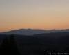
... Morning shift lasted 40 minutes. First, the field, and from the gas distribution station - on the road. So it - the railway station to the city off. Electric, which departs at half past ten, dovozyt us Volosyanki. They expect the following (the village Syanky Lviv region) decided on the slopes of the mountains east of the station. There
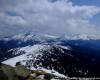
pomyluvalys views on the highest point of the Eastern Beskid Poland -
Mount Tarnytsya on Acute Mountain Polonyna Rivne, Lyutyansku Golitsi in
the western part Poloninska-Montenegrin Carpathians.
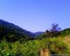
Sanok we got to the train, and a few minutes shifted to another and fell in Sambor. Trip pleased with fantastic surrounding scenery for car windows.
And the green grass over Tura
...
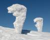
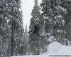
Pivmetrovoyu thickness of snow covered lawn Antalovetskoyi Polana move
from west to east late in November managed to not less than 40 minutes.
Time ran and mileage barely grew. We thought it would have to avoid Sokolets. But adjustments made road. Vity trees that adorn her in October, under the weight of snow lay on the road and made it impassable. Eventually we left the road and decided to pierce Sokoltsya straight line to the ridge above the river ledge Klokotyva.
Over
three hours of competition in thickness of snow underfoot and bent to
the ground vitamy trees still crowned with the release of a cliff ...
From rocky complexes rose in the footsteps of its highest point, and then - in sidlovynu. Path, the comments in October, which, according to our expectations, was reduced to a village, it was impossible to discern. So once again went straight in the north-easterly direction. Fortunately,
quickly went on the road, which originally was blocked bent branches,
but gradually became a good pass and confidently Serpentine beguiled us
down. Shortly appeared open areas from which we watched the majestic snow-capped peaks and Borzhavi Exactly. Far below, above Tura, prohlyadalysya green lawns in the village of Tura Remeta.
Gradually, a layer of snow waxed away, and in the valley Klokotyvy it already was not in general. In the dusk came to mend the road-Svalyava. Twelve hours Snow epic virtually without respite came to an end.
|