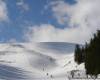
In Gorgan, under the Yaykamy
North-western part of Gorgan - one of the least explored areas in the Carpathians. Lockal
forest preserve their virginity, they encounter numerous
representatives of fauna, including large ungulates and predators. They should often occur in small revenues paths. Instead,
traces of human activity more say thoughtlessly destroying the natural
wealth, rather than a desire to preserve and rationally use the rich
potential nature reserve. My transition was fine for three days of the first decade of October. Thus, even in mild weather, the short daylight hours to overcome the significant distance difficult.
Pustyshak path leads to "Yes"
Myslivka
village located on the route that leads from the city Prikarpatskogo
Valley Torunskyy pass through to the district center of Transcarpathian
Mezhgore, Volovets, Hust. Road
traffic is not the best - Lions coach sent-Justo of the Valley at 11.50
and arrives in Myslivka after the first day, from Ivano-Frankivsk
Uzhgorod single bus pass is about 14.00. Thus, if the place starts to accrue on public transport, the South lost.
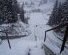
Our walking route starts from the intersection before Myslivka about advertising index, which invites the tourist hotel "Bear". On
the road turn left and go through less than a kilometer to the south,
past the Bear "and mentioned in the August issue of the Carpathians"
manor Victor Medvedchuk priselke Lyudvykivka to the first bridge across
the river candle. The road bridge is marked with yellow markers and leads to the left past the building Lyudvykivskoho Forestry.
Marked trail is ... despite the very fence Forestry and immediately takes up. On the rock next to the yellow marker says "YES!". The
first thing that comes to mind - words made to better target, but then,
rising above, find out: Volunteer organization "Carpathian paths"
markuvaly this route in early December 2004, it is possible that after
returning from the orange square in Kiev and apparently provided the path of political overtones. "Yes"
or another, suffered landmarks correctly, cookies all the time under
review, neat yellow arrows indicate zaschoraz turns on the path that it
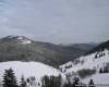
traversuye, the serpentine twists. Forest in the area mixed and pure, almost no trees.
Approximately
forty minutes of moving in a general easterly direction, and then
returns rapidly up the path to the southeast - the 800-meter distance
climb 380 meters. At
the end of this goes to the small snippets of clearing (48,46.828
pn.sh., 23,47.795 E.) 1, in which case adjacent overgrown grass have
not yizhdzhena tractor road. (Apparently,
this road is deposited on top Soviet military "kilometrovkah", which
became the heritage of mankind through the Internet resource Berkeley).
Elevation
is somewhat polohishym, and for some time tractor road goes to the open
terrain at altitudes over 1260 meters, with a view to the west. It
is important not to miss labeled markers Turn right, east to the summit
with a height of 1310 meters (48,46.593 pn.sh., E. 23,48.240 probably a
small Pustyshak) - the road in a southeasterly direction, , the logic had to traversuvaty this peak, then disappears altogether.
Having
risen to a height of 1310 meters, we opynyayemosya at the beginning of
the spine that runs through the Great Pustyshak to Gorgan Ilemske,
extreme summit ridge Arshytsya. Focusing on markers, overcomes two "pleasure" to the Great Pustyshaka miles (1424 meters, 48,46.166 pn.sh., 23,49.279 E.) ...
East - south-east
"Where would not go, do not you driving, and the path spynys" 2 - Look at the compass. In fifty meters east of the summit, with few loose horhannym, and marking, and a clear path ends. The next piece of the route - an excellent site for practicing skills, targeting areas with a compass. With map and compass grid define the direction of movement - east-southeast. In
this case, more detailed orientation is not required because there is
one sure sign - to move the line of the watershed ridge.
Sometimes it ... On the descent of Pustyshaka we stumbled upon a subject that does not leave doubt: the right move. Just in the grass, where there was a bit of the path, lay thin glass bottle with clear liquid. Raised, rozkorkuvaly, ponyuhaly - moonshine! "She napivpovna - shouted one of the parties - let's take ..." "No!" - Categorically cut the rest. Sighed, zakorkuvaly, gently placed in the grass. In many attacks occur various findings and destruction. But even a man with forty years experience hodzhennya mountains are not remembered.
On the descent must overcome storms of small area, overgrown ozhynnyka. Obviously, once this place was a clear path - where some places have survived polish stone columns-markers. So if you move right, these guidelines will meet on the way ...
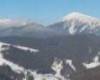
Deceptively temptation Arshytsi
Elevation of the meadows to the top of Gorgan Ilemske lasts about two hours. First, open terrain with little climb move clear path in a southerly direction to the nearest zalisnenoyi peaks. Closer to the border of the forest at an altitude of 1250 meters, the path is lost. Hrebtykom
pidnimayemosya to the forest to the south (left undistinguished path,
to the east, we do not need, it leads to the adjacent mountain slope). In the forest, going ridge, we find ourselves on a clear path. Soon after entering the forest hill height of 1351 meter (48,45.216 pn.sh., 23,51.019 E.). It, incidentally, is also well-preserved ancient fortification frontage.
Pidnimayemosya right slope of the spine in a healthy clean wood, covered with thick soft dark green carpet of grass and moss. In
one place the piece of loose stones, passing, and then quite suddenly
come out of the forest into open ground (1423 feet, 48,44.977 pn.sh.,
23,51.01 E.), which has seen sandwiched kryvolissyam path that leads to
top of Gorgan. Here again we have a chance to verify to what "accurate" is a Soviet map. In
"kilometrovkah" shows that the path of Pustyshaka passes traverses the
top of Gorgan Ilemske from the west at a distance of approximately 400
meters. On the ground, everything is easier and more pleasant - it goes straight to the top ...
Go to Yaiko - if not the best option to continue the route. Less than an hour you can go to the meadows Mszana, and then about two hours to reach Yaiko. But we hired mliyuche lace tops Arshytsya spine. It stretches approximately 12 kilometers from northwest to southeast of Gorgan Ilemske to small mountain (1509 meters). Finally, the continuation of the route of Gorgan and Arshytseyu seemed logical, and cognitive. From the top prohlyadavsya good way to climb the next ridge. Zherep low, approximately meter height. Then, just twenty minutes we were on top of 1576 meters (48,44.230 pn.sh., 23,51.913 E.). Since it outlines further ridge trails only barely visible. Our attempt to get to the next mountain slope circuit ended little fiasco. Alpiyka here goes two and a half meters, fight kryvolissyam vydalosya absurd. Therefore decided to turn right down to the limit of the forest and go straight into the valley of the river Mszana ...
Reserve, mutilated man
Brief description of the route
Village
Myslivka Dolinsky district of Ivano-Frankivsk Oblast (Just Lyudvykivka)
- Big Mountain Pustyshak (1424 feet) - Gorgan Ilemske mountain (1586
meters) - River Valley Mszana - Osmoloda Rozhnyativsky village district
of Ivano-Frankivsk region.
Approximate length of the route 33 miles,
Duration - two or three days. Maximum Vertical drop 930 meters.
Arshytsi down from the river, with pivkilometrovoyu loss of height, took a quarter to two o'clock. In the forest, which rarely tread foot of man, many animal footprints. Occasionally, we found parts of bestial tracks. Obviously, there are many ungulates (wild boar, deer, roe). This
is evidenced not only distinctive hoof prints, but rytvyny after wild
pigs, deer prym'yati grass and pine needles in a few pines, and,
present in naturalism, excrement.
... Marsh terrain proceed to the river at an altitude of 1050 meters, about a mile below the mountain valleys. Then everything is simple and clear: the road along the river down to the southeast. As used in the mountains have to move several times because of the flow of rocks and logs, go channel. Autumn day is short, and to Osmolodi had to take more than seventeen miles. Last minibus from this village went to the village Broshniv that next Kalush, 16.00. Thus,
there was no sense to move in the twilight, and the group chose the
first, better parking space on the shore Mszana (995 meters 48,42.251
pn.sh., 23,52.223 E.). Not far away was heard the noise and hiss timber gasoline saws.
The next day we nadyvylysya the results of human activity in a picturesque corner of nature ...
Not on the itinerary. Seen may be a good illustration of the actual current environmental topics Carpathians. Hectares
vymishanyh tracks and tires clay, branches, trisok, thousands of cubic
abandoned "substandard" timber objectives bald slopes in cluttered
Yaykom Ilemske and Arshytseyu. And dozens of timber every day somewhere export "certified" Carpathian wealth. No doubt that lisozahotivelnyky have all the required permits. And if they do something for the reclamation of the developed areas?
In
neighboring Poland cubic meter of wood forestry sells for 80 zlotys
(approximately 160 USD), and practically no forests Beskidska
suhostoyiv and felling. And how many million USD zihnyvaye forest in the grounds of the Ukrainian Carpathians? And how many thousands of tourists and a jeep could cause such damage to nature, as one team of woodcutters?
In
the tract Far Mszana on the left bank of the river at an altitude of
848 meters is a natural object "Riding the swamp" (48,40.538 pn.sh.,
23,55.301 E.). "Why do they protect the swamp and not protect the forest?" - Wondered one marcher ...
Having gone from a parking space a little over three miles, went to the abandoned buildings hurtozhytskyh woodcutters. Opposite
them the right flows in Mszana Rosohan stream flowing between the
slopes Yayka Ilemske (mountain rises in the west) and Yayka Perehinske
(1600 meters). A
little more than five kilometers along Mszana - and we find ourselves
at a crossroads with a broad road that goes from the river despite
Osmolodi Young southwest (789 meters 48,39.530 pn.sh., 23,56.512 E.). From here turn right towards Osmolodi ...
Special thanks for assistance in preparing this material Alexander Tambovtsev
1Koordynaty submitted in the format of international navigation system WGS 84. The number before the comma indicates degrees, after the comma - minutes after the dot - thousandth minutes; pn.sh. - North latitude, E. - East.
2Tsytata of Soviet propaganda verse.
|